How You Get There...
(The Wedge Overlook)
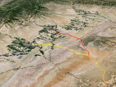
On Highway 6 from Provo When you get to Price, take exit 241 and turn south on Highway 10 to Castle Dale. Drive to Huntington (the sign outside Price says it’s 17 miles); approximately 7 miles further south beyond Huntington you’ll see on the west side of the highway a sign that reads "San Rafael Recreational Access" (this turnoff is about one half mile north of Castle Dale). Turn left and travel east on the unpaved road shortly after the sign. You’ll be driving about 20 miles to the Overlook (the road has been treated with magnesium chloride so it’s pretty smooth and not a lot of dust) just follow the signs (and enjoy the scenery along the way!)
On Highway 10 from I-70 At Fremont Junction, take the exit to Emery/Castle Dale. Approximately one mile north of Castle Dale you’ll see on the east side of the highway a sign that reads "San Rafael Recreational Access". Turn east on the unpaved road shortly after the sign. You’ll be driving about 20 miles to the Overlook (the road has been treated with magnesium chloride so it’s pretty smooth and not a lot of dust) just follow the signs (and enjoy the scenery along the way)!
Finding the Swell is Easy!
|
From SR-10 turn east at either of the Public Lands Access Signs located just north of Castle Dale on SR-10, or on Center Street in Huntington. Follow the signs to the visitors kiosk at Buckhorn Flats. From there head southeast to the Wedge Overlook. The route is well marked with BLM signage, and easy to follow.
|

